Flood Model for Risk Assessment and Infrastructure Planning
Understanding Flood Models for Better Planning and Safety
Flooding is one of the most common and destructive natural disasters worldwide. In India alone, millions of people are affected every year by river overflows, urban waterlogging, and coastal surges.
That's where a flood model becomes critical. It helps predict where water will go, how deep it will be, and what areas are most at risk—long before a single drop falls.
Whether you're planning a highway, designing a residential layout, or preparing a disaster response plan, flood modeling gives you the data you need to build smarter and safer.
What is a Flood Model?
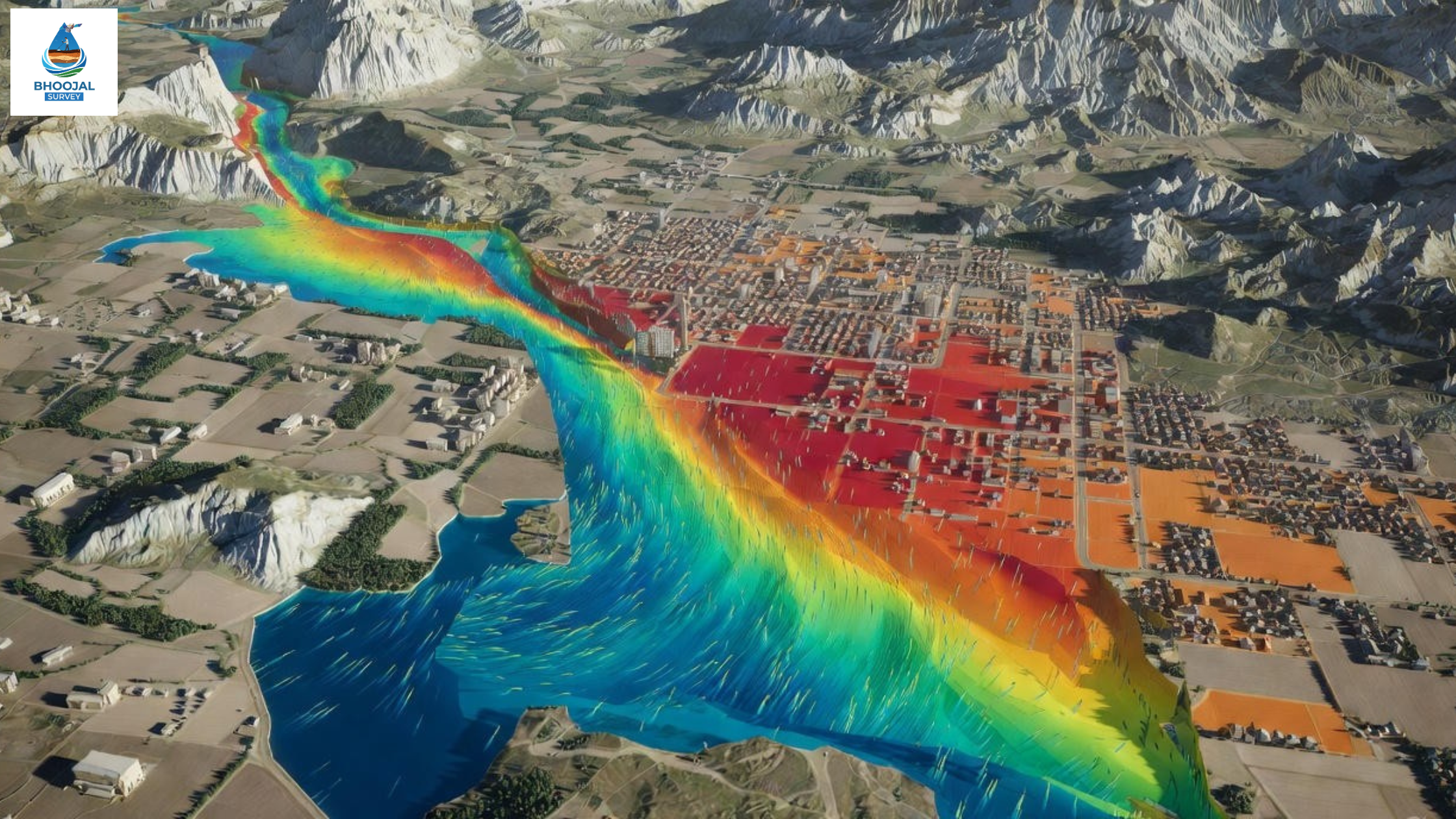
A flood model is a computer-based simulation that replicates how water flows across land during heavy rain, river overflow, or storm surges.
It uses real terrain data, rainfall patterns, river levels, and drainage systems to predict:
- • Which areas will flood
- • How deep the water will be
- • How fast it will move
- • How long it will take to drain
Think of it as a virtual test run for a flood—without the actual damage.
Why Flood Models are Important
Flood modeling isn't just for scientists or disaster agencies. It's now a standard requirement for:
- • Infrastructure projects: Roads, bridges, airports, and pipelines
- • Urban planning: Housing colonies, industrial zones, SEZs
- • Government approvals: Environmental clearances and NOCs
- • Insurance assessments: Understanding flood exposure
- • Disaster preparedness: Evacuation planning and early warning systems
A flood model helps you understand risk before construction begins—saving lives, money, and legal hassles.
Types of Flood Models
Different types of flood models are used depending on the project and location:
1. River Flood Models
Used to study how rivers behave during heavy monsoons or dam releases. Common in projects near Ganga, Yamuna, Brahmaputra, and other major rivers.
2. Urban Flood Models
Focus on stormwater drainage, sewer capacity, and surface runoff in cities. Essential for metro projects, residential layouts, and smart city planning.
3. Coastal Flood Models
Simulate storm surges, tidal flooding, and sea-level rise. Critical for ports, coastal highways, and seaside developments.
How a Flood Model Works
Creating a flood model involves several technical steps, but the process can be simplified into three main stages:
Step 1: Data Collection
- • Topographical survey data (elevation, slope, contours)
- • Satellite imagery and LiDAR data
- • Rainfall records and river discharge data
- • Soil type, drainage network, and land use maps
Step 2: Simulation Process
All data is fed into specialized software like HEC-RAS, MIKE FLOOD, or SWMM. The software runs different flood scenarios—light rain, heavy monsoon, extreme events—and shows how water behaves.
Step 3: Result Interpretation
The model generates flood maps showing:
- • Inundation zones (areas that will flood)
- • Water depth and velocity
- • Risk levels (low, medium, high)
- • Safe zones and evacuation routes
These results are used by engineers, architects, and planners to design flood-proof infrastructure.
Applications of Flood Models
Flood modeling is used across multiple sectors:
- • Government planning: Identifying flood-prone areas for policy and zoning
- • Infrastructure projects: Highways, airports, railways, and dams
- • Urban development: Master plans, township layouts, and drainage design
- • Disaster management: Early warning systems and evacuation planning
- • Environmental impact assessments (EIA): Required for project clearances
- • Insurance and finance: Risk modeling for flood-prone investments
Benefits of Using a Professional Flood Model
Hiring experts for flood modeling gives you several advantages:
- • Accurate risk identification: Know exactly where and how severe floods can be
- • Better decision-making: Choose safer alignments, layouts, and designs
- • Reduced losses: Avoid costly repairs, delays, and liabilities
- • Faster approvals: Meet regulatory requirements with credible data
- • Long-term safety: Build infrastructure that lasts through extreme events
A professional flood model isn't just a report—it's a roadmap for resilient development.
When Do You Need a Flood Model?
You should consider flood modeling if:
- • Your project is near a river, lake, or coastline
- • The site is in a low-lying or historically flood-prone area
- • You're developing urban infrastructure with heavy drainage needs
- • Environmental clearance or EIA requires flood risk assessment
- • You're designing a critical facility like a hospital, airport, or power plant
- • Local authorities have flagged flood concerns
Even if flooding isn't obvious, a flood model can reveal hidden risks that aren't visible on the ground.
Why Flood Models Matter
Climate change is making floods more frequent and unpredictable. What was safe 10 years ago may not be safe today.
A flood model gives you the foresight to plan ahead. It helps governments protect communities, developers build responsibly, and engineers design with confidence.
At Bhoojal Survey, we specialize in hydraulic flood modeling, flood risk analysis, and flood hazard mapping using the latest GIS and remote sensing tools. Our flood modeling services support infrastructure projects, urban planning, and disaster preparedness across India.
Our Expertise in Flood Modeling
- • River and urban flood simulation
- • Flood hazard and inundation mapping
- • Drainage network analysis
- • Integration with topographical and satellite data
- • Regulatory compliance and EIA support
Whether you're planning a new highway, designing a township, or preparing a disaster management plan, expert flood modeling ensures your project is built on solid ground—literally.
Call +91-96918 58058