


Understanding Flood Risk in Assam
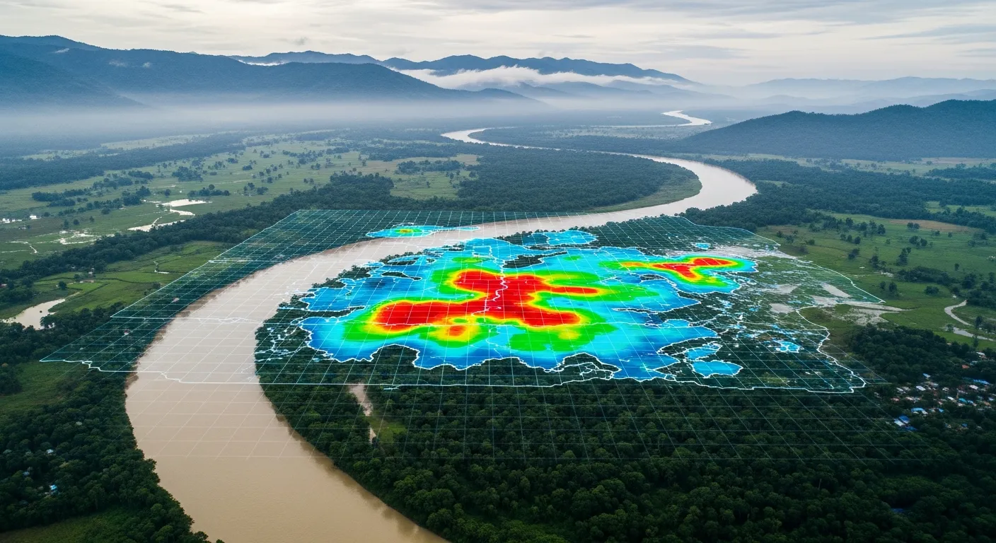
Assam faces some of India's most severe and recurring floods every year. The mighty Brahmaputra river, combined with extreme monsoon rainfall and tributaries flowing from the Himalayas, creates a complex flooding situation that affects millions of people across the state. Flood risk assessment helps us understand where flooding will strike, how severe it will be, and what we can do to protect lives, homes, infrastructure, and livelihoods before disaster arrives.
This scientific process involves studying rainfall patterns, river behavior, land elevation, soil characteristics, drainage systems, and decades of historical flood data. The goal is simple but critical: predict flooding accurately so that government authorities, builders, farmers, and communities can make informed decisions about construction, emergency planning, and infrastructure design.
Why Flood Risk Assessment is Critical in Assam
Assam's geography makes it uniquely vulnerable to flooding. The Brahmaputra river system, one of the world's largest, flows through the heart of the state carrying massive volumes of water and sediment from the eastern Himalayas. During monsoon season, this already powerful river system swells dramatically, often breaching its banks and inundating vast areas.
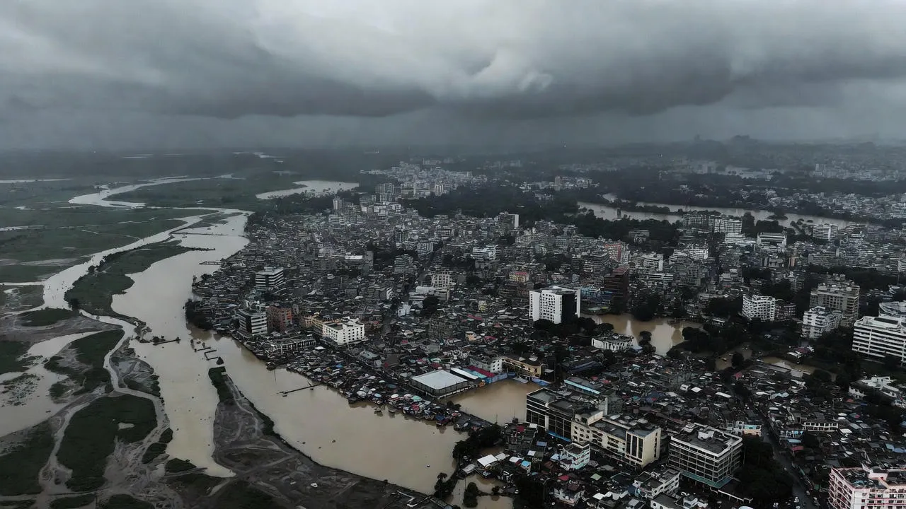
Every year, floods disrupt normal life across Assam. Roads and bridges get washed away, cutting off entire districts. Agricultural fields disappear under water for weeks, destroying crops that families depend on. Schools and hospitals become inaccessible. Oil refineries and tea gardens face operational challenges. Urban areas like Guwahati experience severe waterlogging that paralyzes the city for days.
Major Challenges Assam Faces:
The state confronts multiple flooding challenges simultaneously. Extreme monsoon rainfall concentrated in just a few months delivers enormous water volumes that overwhelm natural drainage. The Brahmaputra carries heavy sediment loads that raise the riverbed over time, reducing its capacity and increasing overflow risk. Flash floods from Himalayan tributaries arrive suddenly with little warning, devastating downstream areas.
Riverbank erosion continuously changes the landscape, destroying villages and farmland while creating new flood pathways. Upstream developments and dam operations in neighboring regions affect water flow patterns in Assam. Wetlands and natural floodplains that once absorbed excess water are increasingly being encroached upon for agriculture and construction. Urban areas expand without adequate drainage infrastructure, making cities highly vulnerable to waterlogging.
Flood-Prone Cities and Regions of Assam
Different parts of Assam experience different types and severities of flooding. Understanding these regional patterns is essential for effective flood risk planning and management.
Guwahati and Urban Flood Zones
Guwahati, Assam's largest city, faces severe urban flooding almost every monsoon. The city sits in a bowl-shaped terrain surrounded by hills, with numerous natural drainage channels flowing through it. Rapid urbanization has blocked many of these channels, filled up wetlands, and covered natural drainage areas with concrete.
When heavy rain falls, water has nowhere to go. Areas like Ganeshguri, Christianbasti, Maligaon, Khanapara, and many localities near the Bharalu river experience hours or even days of waterlogging. Traffic comes to a standstill. Homes and shops get inundated. The city's drainage system, designed decades ago, cannot handle today's rainfall intensities and urban expansion.
Brahmaputra Riverine Flood Zones
Districts along the Brahmaputra and its tributaries face the most extensive flooding. Dhemaji, Lakhimpur, Majuli, Jorhat, Golaghat, Nagaon, and Morigaon experience regular inundation when the river overflows during peak monsoon. These are primarily agricultural areas where entire villages can remain submerged for weeks.
Majuli, the world's largest river island, faces a dual threat from flooding and erosion. Every year, the island loses land to the Brahmaputra while flooding affects the remaining inhabited areas. The people of Majuli have adapted to living with floods, but the recurring nature of these events causes immense hardship and economic loss.
Lower Assam Districts
Barpeta, Nalbari, Bongaigaon, Dhubri, and Goalpara in Lower Assam face flooding from both the Brahmaputra and its southern tributaries. The terrain here is relatively flat with numerous wetlands and char areas (temporary islands formed by river sediment). During floods, vast stretches become one continuous body of water.
The char dwellers, who live on these temporary islands, face particular vulnerability. Their settlements exist in a state of constant uncertainty, knowing that flooding or erosion could force them to relocate at any time. Yet they continue to cultivate these fertile lands during the dry season, taking calculated risks for their survival.
Barak Valley Region
The Barak valley in southern Assam, including Silchar, Cachar, Karimganj, and Hailakandi districts, faces a different flooding pattern. The Barak river and its tributaries create widespread inundation during monsoon. Silchar city experiences regular urban flooding that disrupts life and commerce.
The valley's low-lying geography means that water accumulates and drains slowly. Areas remain waterlogged long after the rain stops, creating prolonged hardship. Road connectivity between the valley and the rest of Assam often gets disrupted during severe floods, effectively isolating the region.
Major Causes of Flooding in Assam
Understanding why Assam floods so severely helps in developing effective assessment and mitigation strategies.
Extreme Monsoon Rainfall and Upstream Inflow
Assam receives some of the heaviest rainfall in India, concentrated mainly between May and September. The state sits at the junction of multiple weather systems that deliver intense precipitation. When heavy rain falls across the Brahmaputra basin, both in Assam and in upstream areas of Arunachal Pradesh and Tibet, enormous volumes of water converge in Assam's river systems.
The timing matters critically. If heavy rainfall occurs simultaneously across the entire basin, the cumulative effect creates devastating floods. Multiple tributaries contribute peak flows to the Brahmaputra at the same time, overwhelming its capacity.
Brahmaputra Sedimentation and Riverbed Rise
The Brahmaputra carries one of the world's highest sediment loads. Every year, millions of tons of sediment from eroding Himalayan slopes get deposited in the river channel. This continuous deposition gradually raises the riverbed, reducing the channel's water-carrying capacity.
As the riverbed rises, the same amount of water creates higher flood levels and more frequent overtopping of embankments. Dredging provides temporary relief but cannot keep pace with the continuous sediment inflow. This is a fundamental challenge that makes Assam's flood problem particularly difficult to solve permanently.
Flash Floods from Himalayan Tributaries
Rivers like Subansiri, Manas, Jia Bharali, Dhansiri, and Kopili originate in the steep Himalayan foothills. When intense rainfall occurs in these catchments, water rushes down with tremendous force as flash floods. These events develop within hours, giving little time for warning or evacuation.
Flash floods are particularly dangerous because of their speed and power. They can wash away bridges, roads, and settlements in their path. The suddenness makes them especially threatening to life and property.
Unplanned Urban Growth and Drainage Failure
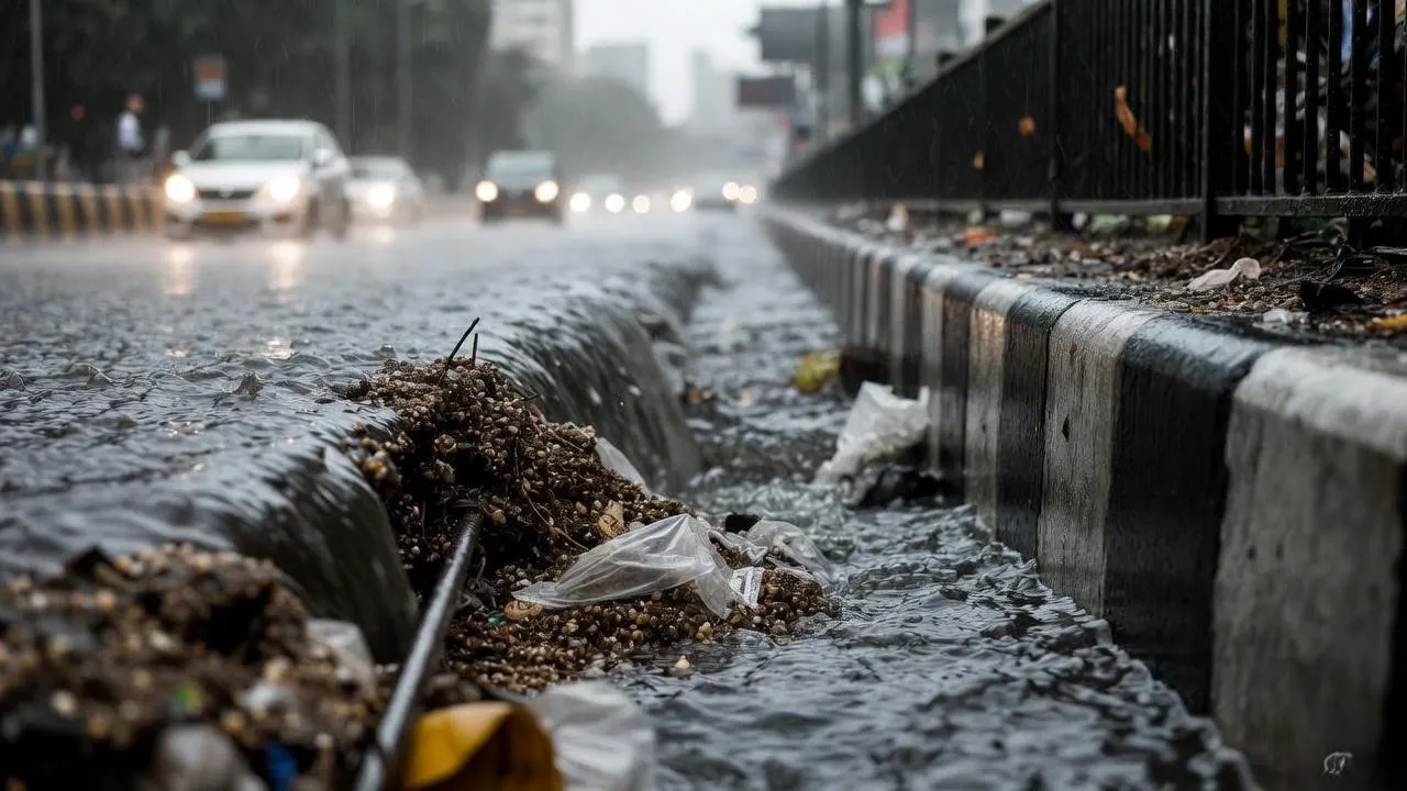
Cities like Guwahati have expanded rapidly without corresponding investment in drainage infrastructure. Natural water channels have been encroached upon or filled up. Wetlands that once acted as natural retention basins now have buildings on them. The result is that rainwater cannot drain naturally, causing severe waterlogging even during moderate rainfall.
Inadequate maintenance of existing drainage systems compounds the problem. Drains get clogged with garbage and silt, reducing their effectiveness. During heavy rain, these systems fail completely, turning roads into rivers and low-lying areas into temporary lakes.
What is Flood Risk Assessment?
Flood risk assessment is a comprehensive scientific analysis that evaluates how vulnerable a specific location or region is to flooding. It goes beyond simply predicting whether flooding will occur to understanding the depth of water, the speed of flow, how long water will remain, which areas face the highest danger, and what the potential impacts will be.
The process involves three main components working together. Flood hazard identification determines where flooding can physically occur based on terrain, river systems, rainfall patterns, and historical data. Flood vulnerability mapping assesses what and who will be exposed to flooding including people, buildings, infrastructure, agricultural land, and economic activities. Risk analysis combines these factors to prioritize areas and recommend appropriate protective measures.
How Flood Risk Assessment is Conducted in Assam
Professional flood risk assessment follows a systematic methodology using modern technology and scientific analysis.
Data Collection Phase
The process begins with gathering comprehensive data about the area under study. This includes rainfall records from weather stations showing patterns over many years, river discharge measurements indicating how much water flows during different seasons, satellite imagery and topographic maps showing land elevation and slope, soil type information affecting water absorption, existing drainage network details, and historical flood records documenting past events.
For Assam specifically, data from the Brahmaputra Board, Central Water Commission, India Meteorological Department, and State Disaster Management Authority provide crucial information. Local knowledge from communities that have experienced floods for generations also adds valuable insights that pure data might miss.
Satellite and GIS Analysis
Geographic Information Systems allow experts to create detailed digital models of the landscape. High-resolution elevation data shows exactly how land slopes and where low points exist where water will naturally collect. Analysis of river channels reveals capacity, meandering patterns, and erosion-prone sections.
Satellite imagery taken during past floods shows actual inundation patterns, providing validation for models. Changes in land use over time can be tracked to understand how urbanization or deforestation might have altered flood behavior. The analysis identifies natural drainage pathways and potential bottlenecks where flow gets restricted.
Hydrological and Hydraulic Modeling
Computer models simulate how water moves across the landscape under different scenarios. Hydrological models calculate how much rainfall will convert to runoff versus absorption based on soil conditions and land cover. Hydraulic models track how this water flows through rivers and across floodplains, calculating depth, velocity, and extent of inundation.
Multiple scenarios get tested representing normal monsoon conditions, heavy rainfall years, extreme events, and combinations with upstream developments. For Assam, models must account for the Brahmaputra's unique characteristics including its braided channel pattern, high sediment load, and the influence of multiple tributaries joining simultaneously.
Flood Risk Interpretation and Mapping
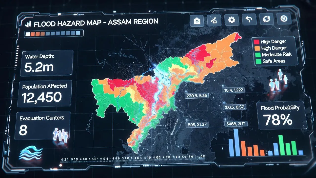
The analysis results get translated into easy-to-understand flood risk maps. Areas are typically classified into zones: high risk where flooding occurs frequently with significant depth and damage potential, moderate risk where flooding happens occasionally or with lesser severity, and low risk where flooding is rare or minor.
These maps show not just which areas will flood but provide specific information like expected water depths, flow velocities, duration of inundation, and recommended safe ground levels for construction. This actionable information guides all subsequent planning and design decisions.
Applications of Flood Risk Assessment in Assam
Flood risk assessment provides essential guidance for multiple types of development and planning across Assam.
Urban Planning and Master Plans
City authorities use flood risk maps to designate zones for different types of development. High-risk areas can be designated as green spaces, parks, or recreational facilities that can tolerate temporary flooding. Medium-risk zones might allow development with specific flood-proofing requirements like elevated foundations. Low-risk areas become preferred locations for critical infrastructure like hospitals, fire stations, and emergency shelters.
For Guwahati and other urban centers, understanding drainage patterns helps prioritize infrastructure investments. Widening bottleneck sections, restoring natural channels, and upgrading drainage capacity in critical areas become evidence-based decisions rather than guesswork.
Highway and Bridge Projects
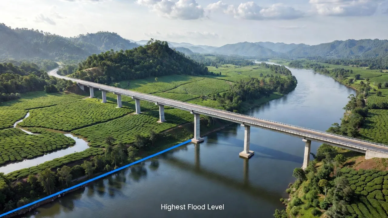
Transportation infrastructure must withstand Assam's flooding to maintain connectivity during emergencies. Flood risk assessment determines appropriate bridge heights so they remain above peak water levels, identifies alternative routes for redundancy, and guides the design of adequate culverts and drainage structures along highways.
The assessment helps engineers understand maximum expected flow velocities and depths, ensuring bridge foundations and approaches can resist flood forces. This prevents the costly failures and lengthy disruptions that occur when infrastructure gets washed away.
Industrial and Oil-Gas Infrastructure
Assam's oil refineries, tea processing facilities, and industrial units need protection from flooding to maintain operations and prevent environmental hazards. Flood risk assessment guides site selection, ensuring new facilities locate outside high-risk zones or on elevated ground.
For existing facilities, the assessment identifies vulnerabilities and recommends protective measures such as boundary walls, elevated equipment mounting, waterproof electrical systems, and emergency shutdown procedures. Oil storage areas and hazardous material handling zones receive special attention to prevent contamination during floods.
Hydropower and Riverfront Development
Hydropower projects on Assam's rivers need careful flood analysis to design appropriate spillway capacity, prevent downstream flooding from operations, and protect dam structures from extreme events. Riverfront developments along the Brahmaputra and other rivers must account for flooding and erosion to ensure long-term viability.
Disaster Management Planning
State and district disaster management authorities use flood risk maps to develop evacuation plans, position relief materials in strategic locations, establish early warning systems with appropriate lead times, and train communities on flood preparedness. Knowing exactly which areas will flood and in what sequence allows authorities to act proactively rather than reactively.
Benefits for Projects and Authorities
Investing in professional flood risk assessment delivers tangible benefits that far outweigh the costs.
Reduced Flood Damage and Financial Loss
Projects designed with flood risk in mind experience significantly less damage when floods occur. Elevated buildings stay dry while neighbors flood. Properly sized drainage prevents waterlogging. Protected infrastructure continues functioning. The savings from avoided damage and business interruption quickly justify the assessment investment.
Faster Statutory Approvals
Regulatory authorities increasingly require flood risk documentation for project approvals, especially near rivers and in known flood zones. Projects that submit comprehensive flood risk assessments move through approval processes faster with fewer questions and objections. The assessment demonstrates due diligence and responsible planning.
Safer Infrastructure Design
Engineers design better when they have accurate flood data. Foundation depths, drainage capacities, protection levels, and emergency systems all get properly sized. This creates safer infrastructure that protects users during floods rather than endangering them.
Long-Term Resilience and Sustainability
Projects built with flood awareness remain viable for decades despite recurring floods. They avoid the costly cycle of damage and repair that plagues developments built without proper assessment. This long-term thinking creates sustainable infrastructure that serves communities reliably year after year.
Importance of Professional Flood Risk Assessment
While it might be tempting to cut corners or rely on informal assessment, professional flood risk assessment provides critical value that amateur efforts cannot match.
Accurate Flood Modeling
Professional assessors use validated models and methodologies that accurately represent Assam's complex flood dynamics. They understand the Brahmaputra's behavior, tributary interactions, sediment effects, and regional rainfall patterns. Their experience prevents critical mistakes that could leave projects vulnerable.
Authority-Accepted Reports
Reports prepared by qualified professionals meet regulatory standards and formats that authorities expect. They include all necessary technical details, calculations, maps, and recommendations in formats that gain acceptance from state departments, pollution control boards, and disaster management authorities.
Expert Mitigation and Design Recommendations
Beyond identifying risk, professionals provide practical solutions tailored to Assam's conditions. They recommend appropriate drainage designs, flood protection levels, site grading, emergency access routes, and construction techniques that work in local soil and flood conditions. This guidance translates technical analysis into actionable engineering and planning decisions.
Building Flood-Resilient Assam
Assam will always face flooding given its geography and the mighty Brahmaputra flowing through its heart. However, the severity of impacts can be dramatically reduced through systematic flood risk assessment and intelligent planning.
Climate change may intensify rainfall extremes and alter monsoon patterns, making historical flood data alone insufficient for planning. Professional assessment must now incorporate climate projections and design for greater extremes than the past has shown. This forward-looking approach ensures infrastructure remains safe for decades ahead.
Every new project in Assam should begin with proper flood risk assessment. Whether it's a residential colony in Guwahati, an industrial facility in Dibrugarh, a highway bridge over a tributary, a tea garden expansion in Jorhat, or a hydropower plant on the Subansiri, understanding flood risk must be the foundation of planning.
State and district authorities need updated flood risk maps covering the entire state at appropriate detail levels. These maps should guide all development planning, infrastructure investment, and disaster preparedness activities. Communities in high-risk zones need support for flood-proofing homes, developing early warning systems, and creating safe evacuation procedures.
With comprehensive flood risk assessment becoming standard practice across Assam, we can protect more lives, reduce economic losses, maintain connectivity during floods, and build a more resilient state. The floods will come, but we can be prepared.
Bhoojal Survey's Expertise in Assam
Bhoojal Survey brings extensive experience in flood risk assessment across Assam's diverse and challenging flood environments. Our team combines deep understanding of the Brahmaputra river system, advanced GIS and hydrological modeling capabilities, and practical knowledge of Assam's unique flooding patterns to deliver reliable, authority-accepted flood risk studies.
We have worked on projects spanning urban flood assessments in Guwahati and Silchar, riverine flood studies along the Brahmaputra corridor from Dhemaji to Dhubri, infrastructure projects including highways and bridges across major flood-prone zones, industrial site assessments for oil refineries and manufacturing facilities, and hydropower feasibility studies on Himalayan tributaries. Our flood risk assessments meet regulatory requirements and provide practical engineering guidance that helps projects succeed despite Assam's challenging flood environment.