Introduction
In the realm of modern land surveying techniques, satellite surveying emerges as a revolutionary method that amalgamates cutting-edge technology with precision-driven methodologies. But what exactly does it entail, and how does it work? Let's embark on a comprehensive journey into the intricacies of ground water using satellite survey, delving deeper into its equipment, multifaceted applications, and the nuanced aspect of accuracy.
Understanding Satellite Surveying
Satellite surveying, alternatively termed as satellite remote sensing, encompasses a sophisticated process that leverages satellite imagery and data to glean insights into the Earth's surface. These satellites orbit the planet, tirelessly capturing high-resolution images and collecting a plethora of data types crucial for surveying endeavours.
How It Works: Satellites, equipped with advanced sensors, perpetually capture images of the Earth's surface from the expansive vantage point of space. These images, meticulously processed and analysed utilising specialised software, unveil precise geographic information, including but not limited to topography, land cover, and land use.
Equipment Utilised in Satellite Surveying
- 1. Satellites: Serving as the backbone of satellite surveying, satellites exist in various typologies, ranging from optical to radar satellites, each proffering unique capabilities tailored for diverse surveying applications.
- 2. GPS Receivers: Global Positioning System (GPS) receivers play an indispensable role in accurately determining the location of ground control points and reference markers pivotal in the processing of satellite imagery.
- 3. Imaging Sensors: These sensors, imbued with remarkable prowess, capture images of the Earth's surface across different spectral bands encompassing visible, infrared, and microwave wavelengths, thereby furnishing invaluable insights into terrain features, vegetation, and land characteristics.
Applications Galore: Satellite Surveying at Work
The applications of satellite surveying reverberate across a plethora of industries and sectors, heralding a new era of precision and efficiency:
- 1. Urban Planning: Urban planners harness the power of satellite imagery to meticulously assess land use patterns, monitor the trajectory of urban expansion, and devise cogent strategies for infrastructure development projects with heightened efficacy.
- 2. Agriculture: Farmers and agronomists alike leverage satellite data for a myriad of purposes, spanning crop monitoring, yield prediction, and the implementation of precision agriculture methodologies, thereby optimising resource allocation and bolstering agricultural productivity.
- 3. Environmental Monitoring: The pivotal role of satellite surveying in environmental stewardship cannot be overstated. Satellite-derived data facilitates real-time monitoring of environmental changes such as deforestation, land degradation, and the aftermath of natural calamities, thereby empowering stakeholders to undertake timely interventions and formulate robust conservation strategies.
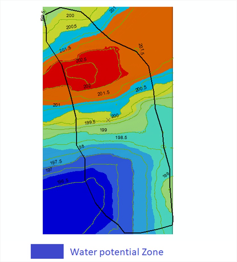
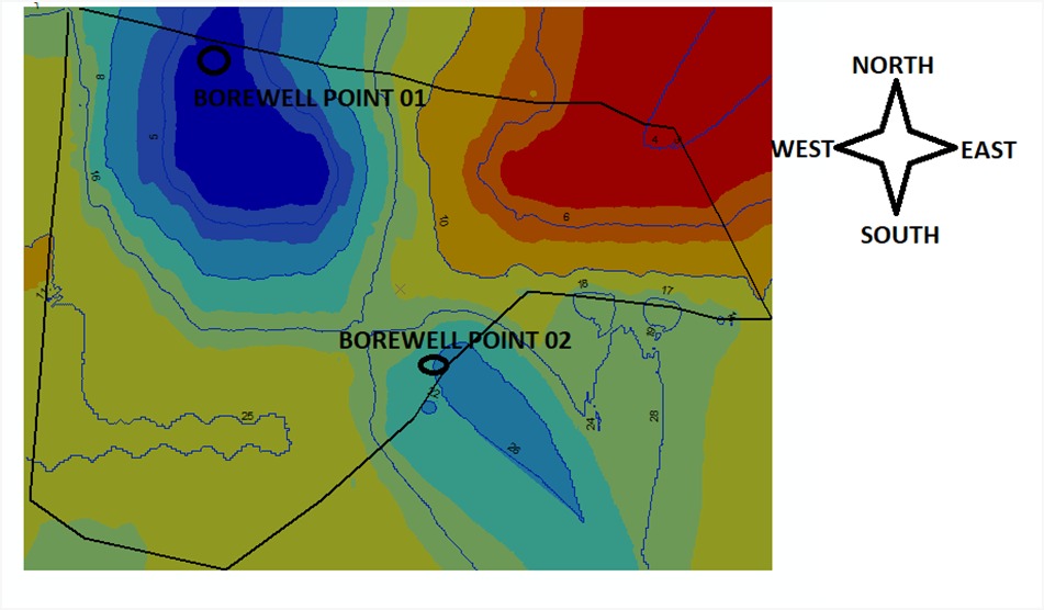
 Water Potential Zone
Process of water detection through Satellite Survey
Detecting water through satellite surveys involves a multi-step process that leverages various satellite sensors and image processing techniques. Here's a general overview of the process:
- 1.Satellite Selection: Choose a satellite equipped with sensors capable of detecting water features. Some commonly used satellites for water detection include Landsat, Sentinel-2, MODIS (Moderate Resolution Imaging Spectroradiometer), and SAR (Synthetic Aperture Radar) satellites.
- 2.Acquisition of Satellite Imagery: Obtain recent and relevant satellite imagery covering the area of interest. Ensure that the imagery has appropriate spatial and spectral resolutions for water detection purposes.
- 3.Pre-processing: Pre-process the satellite imagery to correct for atmospheric interference, sensor noise, and geometric distortions. This step ensures that the imagery is suitable for accurate analysis.
- 4.Image Enhancement: Enhance the satellite imagery to improve the visibility of water features. This may involve techniques such as contrast enhancement, color balancing, and sharpening to highlight water bodies against the surrounding land.
- 5.Water Detection Algorithms: Apply specialised algorithms designed to detect water bodies in satellite imagery. These algorithms utilise spectral signatures and spatial characteristics of water to differentiate it from other land cover types. Common algorithms include thresholding, spectral indices (e.g., NDWI - Normalised Difference Water Index), and machine learning-based classifiers.
- 6.Classification and Segmentation: Classify the pixels or segments identified as water using the detection algorithms. This step separates water pixels from other land cover types present in the imagery.
- 7.Validation: Validate the accuracy of the water detection results through ground truthing or comparison with existing datasets such as aerial photography or field surveys. This helps assess the reliability of the detected water features.
- 8.Mapping and Analysis: Map the detected water bodies and analyze their spatial distribution, size, and temporal dynamics. This information can provide insights into water resources management, environmental monitoring, and land use planning.
- 9.Integration with Geographic Information Systems (GIS): Integrate the water detection results with GIS software to perform spatial analysis, overlay with other geographic datasets, and generate thematic maps for decision-making purposes.
- 10.Reporting and Visualization: Present the water detection findings in a comprehensive report or interactive visualisation tool. Communicate the results to stakeholders, policymakers, and the public to raise awareness and support informed decision-making regarding water resources management and environmental conservation.
Peering into Precision: How Accurate Is Satellite Surveying?
The veracity of satellite surveying hinges upon a myriad of factors, chief among them being the resolution of satellite imagery, the quality of ground control points, and the fidelity of data processing methodologies. In a broader context, satellite surveying stands poised to deliver accuracies ranging from a few metres to sub-centimeter levels, contingent upon the specific requisites of the surveying project at hand.
Factors Underpinning Accuracy:
- 1.Satellite Resolution: The degree of spatial resolution inherent in satellite imagery profoundly influences the granularity and precision of Earth surface mapping endeavours.
- 2.Ground Control Points: The judicious selection and precise surveying of ground control points serve as linchpins in the georeferencing process, thereby bolstering the overall accuracy of satellite-derived data.
- 3.Data Processing Methodologies: The employment of sophisticated data processing algorithms and techniques, encompassing image rectification, orthorectification, and geometric correction, serves to augment the accuracy of satellite-derived information manifolds.
Conclusion
In summation, satellite land surveying emerges as a transformative paradigm that not only revolutionises the domain of geographic information gathering but also fosters sustainable development endeavours on a global scale. With its diverse array of applications and the relentless march of technological innovation, satellite surveying stands as a testament to humanity's indomitable spirit of exploration and inquiry.
How Bhoojal Survey can help you with groundwater detection using satellite survey?
Bhoojal Survey, fortified by a confluence of cutting-edge satellite surveying technologies and a seasoned cadre of experts, stands poised to unravel the enigma of groundwater detection with unprecedented precision and efficacy. Through the judicious deployment of advanced data analysis and interpretation methodologies, Bhoojal Survey endeavours to furnish clients with actionable insights into groundwater availability and distribution, thereby empowering stakeholders to make informed decisions pertaining to water resource management and conservation initiatives. With our unwavering commitment to excellence and sustainability, Bhoojal Survey pledges to be your steadfast ally in the pursuit of unlocking the untapped potential of groundwater resources for the betterment of future generations.
How do you detect the presence of underground water?
Techniques like electrical resistivity surveys, seismic surveys, and analysis of satellite imagery are used to detect underground water.
FAQs (Frequently Asked Questions): Satellite Survey
Q: Can satellite surveying be seamlessly integrated with traditional surveying methodologies?
A: Indeed, satellite surveying can be synergistically fused with traditional surveying techniques, thereby augmenting the precision and scope of land surveying endeavours.
Q: Are there any regulatory hurdles associated with the utilisation of satellite surveying technology?
A: While regulatory frameworks may vary across jurisdictions, the overarching trend underscores a growing acceptance and embrace of satellite surveying technology as a potent tool for socioeconomic development and environmental stewardship.
Q: What distinguishes satellite surveying from other forms of remote sensing techniques?
A: Satellite surveying, owing to its expansive spatial coverage and unparalleled scalability, stands as a preeminent modality within the broader realm of remote sensing, catering to a diverse array of applications spanning land surveying, environmental monitoring, and urban planning domains.
To download as a pdf Click Here

