Understanding Hydrogeological Surveys and Their Role in Groundwater Management
- Home
- Blogs

Watch: How We Conduct Surveys
Introduction to Hydrogeology
Hydrogeology is the specialized branch of geology that focuses on the distribution, movement, and quality of groundwater beneath the Earth's surface. Understanding this field is crucial for the following reasons:
- Bridge between Surface and Subsurface: It connects surface water (rain, rivers) with underground aquifers.
- Recharge Analysis: It explains how water migrates through various soil layers and rock strata.
- Water Security: In an era of global water scarcity, it provides the scientific basis for predicting water storage and availability.
- Sustainability: It helps determine if water is safe for consumption and prevents over-extraction.
What is a Hydrogeological Survey?
A hydrogeological survey is a scientific investigation performed by a qualified hydrogeologist. Instead of guessing, we use data and physics. Key aspects include:
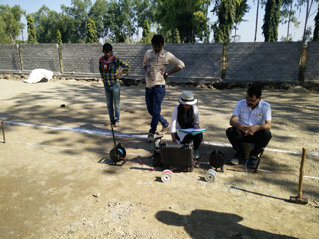
- Scientific Investigation: It uses advanced geophysical instruments to map the underground.
- Methodology: Techniques like Vertical Electrical Sounding (VES) and resistivity meters are used.
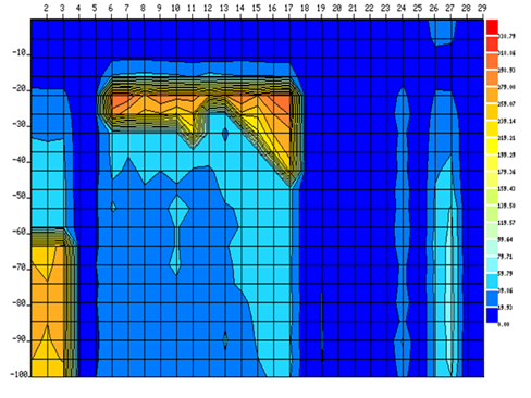
- Principle: Since water conducts electricity better than dry rock, instruments detect low-resistivity zones (fractures).
- Objective: To locate water-bearing strata (aquifers) for successful borewell drilling.
The Step-by-Step Process of a Hydrogeological Survey
Conducting a professional hydrogeological survey involves a meticulous approach:
- Desktop Study: Reviewing topographical maps, satellite imagery, and existing geological data before visiting the site.
- Site Reconnaissance: Physical inspection of the terrain, existing wells, vegetation, and soil type.
- Geophysical Investigation: Deploying instruments to measure electrical resistivity of subsurface layers.
- Data Analysis: Processing raw data using software (like IPI2win) to create 2D/3D underground models.
- Reporting: Generating a final report with GPS coordinates for drilling and expected yield.
What is the Cost of a Hydrogeological Survey?
The cost varies based on several factors, but here is a general breakdown:
- Price Range: typically between ₹10,000 to ₹50,000 for field operations.
- Factors Influencing Cost: Total land area, terrain complexity, and number of survey points.
- Value for Money: Compared to the lakhs spent on drilling a "dry borewell," a survey is a small investment to ensure success.
Importance of Hydrogeological Survey
Conducting a survey prior to drilling is vital for several reasons:
- Groundwater Management: Helps in making informed decisions to prevent depletion.
- Risk Reduction: Minimizes financial loss by avoiding drilling in dry zones.
- Contamination Assessment: Identifies potential pollutant sources to protect water quality.
- Precision Drilling: Provides specific recommendations for depth and casing.
- Aquifer Modeling: Essential for territorial planning and hydrodynamic studies.
Scientific Survey vs. Traditional Methods
Why should you choose science over traditional "water divining"?
- Traditional Methods: Rely on coconut or copper rods (dowsing). They lack scientific backing and often fail in hard rock terrains.
- Scientific Surveys: Use physics to measure electrical properties of rocks.
- Accuracy: Scientific methods increase success rates from random chance to over 90% accuracy.
What is the Role of a Hydrogeologist?
A hydrogeologist acts as a detective of the underground world. Their key responsibilities include:
- Site Inspection: Evaluating surface geology and terrain.
- Locating Water: Using tools to find aquifers.
- Rainwater Harvesting: Designing structures to replenish groundwater.
- Modeling & Testing: Simulating water scenarios and testing well yield.
- GIS Mapping & Reporting: Creating digital maps and detailed survey reports.
Understanding the Hydrogeological Survey Report
The survey report is a critical document for drilling and regulatory compliance (NOC). It includes:
- Local Geology: Types of rocks (Basalt, Granite, etc.).
- Hydrogeological Setup: Depth and arrangement of water-bearing zones.
- Water Quantum: Estimated yield in Liters Per Hour (LPH).
- Technical Details: Resistivity graphs, lithology details, and fractured zone identification.
- Recommendations: Type of borewell rig and casing depth required.

Why Choose Bhoojal Survey?
- Experience: Over 10 years of experience serving 10,000+ clients.
- Expertise: Team of senior hydrogeologists and geophysicists.
- Technology: Equipped with the latest resistivity meters and software.
- Comprehensive Solutions: From exploration to rainwater harvesting and compliance.
Applications of Hydrogeological Surveys
These surveys are used in various sectors:
- Agriculture & Domestic: Finding permanent water sources for farming and housing.
- Artificial Recharge: Designing shafts to put rainwater back into the earth.
- Construction: Ensuring high water tables don't damage building foundations.
- Environmental Protection: Monitoring pollution migration from industries.
- Flood Modeling: Predicting flood risks in low-lying areas.
Conclusion
A hydrogeological survey is an investment in water security. By leveraging the expertise of Bhoojal Survey, you ensure sustainability, save money on failed drilling, and contribute to better groundwater management. Whether for agriculture, industry, or residential use, a scientific approach is the key to a reliable water supply.
Get Free Expert Assistance
Fill the details below for a callback.
