Objective of Ground Water Survey:
To delineate saturated fracture zones in hard rocks and to estimate the thickness of weathered zones. To determine Depth of Aquifers , thickness of aquifer and suitable borewell point location
Principles of Measurement for Ground water exploration :
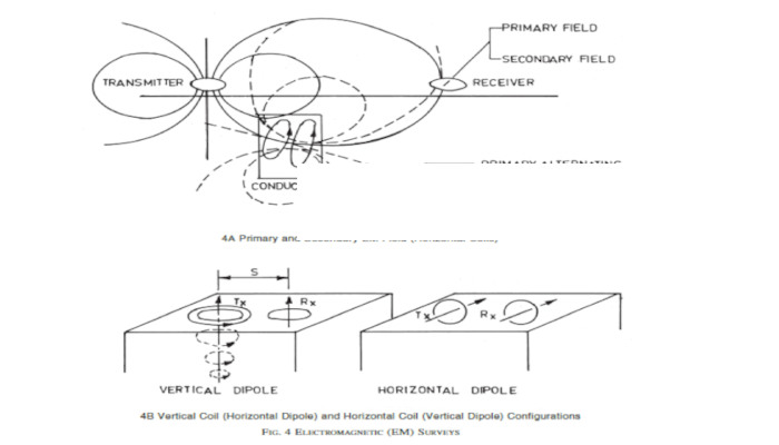
In conventional electromagnetic (EM) surveys a transmitter radiates electromagnetic waves (primary field) that penetrate the ground. When the primary field encounters a conductor, that is, a body of limited extensions with an electrical conductivity higher than its surroundings, eddy currents are produced in the conductor.
A secondary electromagnetic field (in a direction opposite to the primary at the conductor) is produced by the eddy currents and the resultant field is measured by a receiver, placed at a given distance, in the form of in-phase and quadrature components [see Fig. 4A]. The receiver also measures the primary field.
The resultant field is either measured as a percentage of the primary field or its direction relative to the vertical is recorded. The magnitude, direction and phase angle (which is the time delay of the resultant field in relation to the primary field) of the resultant field can be used to locate a conductive body and obtain its parameters. There are several ways to conduct EM surveys by varying the position and orientation of receiver and transmitter loops, namely, vertical loop, horizontal loop, Turam, etc [see Fig. 4B].
Overall, in EM exploration it is generally assumed that there exists a conductivity variation in the subsurface and that the conductive target is located within a non-conducting (resistive) surrounding, or that the conductivity of the target is much higher than the surrounds.
The EM method has advantages over the resistivity method in that the latter has difficulties in sending a current through a highly resistive surface layer, such as those often found in deserts or in compact rocky terrains.
Also, the change in penetration depth can be obtained by changing the frequency of the transmitted electromagnetic wave, as well as the transmitter receiver coil separation. Because anomalies ongroundwater targets in hard rocks are caused by conductivity contrasts between the saturated zone and the surrounding dry medium, a higher contrast would provide a better response.
The electromagnetic method has been used widely in groundwater exploration, occasionally to compliment the resistivity method and help resolve ambiguities in interpretation. A commonly used technique is the Horizontal Loop Electromagnetic (HLEM) method, also known as the Slingram method. HLEM surveys are controlled-source surveys in which the transmitter can be operated at a number of frequencies and transmitter-receiver coil separations. The transmitter and receiver coils are placed in the same horizontal plane.
HLEM profiling with a number of frequencies and transmitter-receiver separations gives a depth-wise distribution of electrical conductivity. That is, a reduction in the frequency of EM waves and/or an increase in the transmitter-receiver separation would provide deeper information. As in resistivity surveys, a conductive overburden of varying thickness can create a problem in quantitative
Ground Water Surveying Instrument Working Procedure:
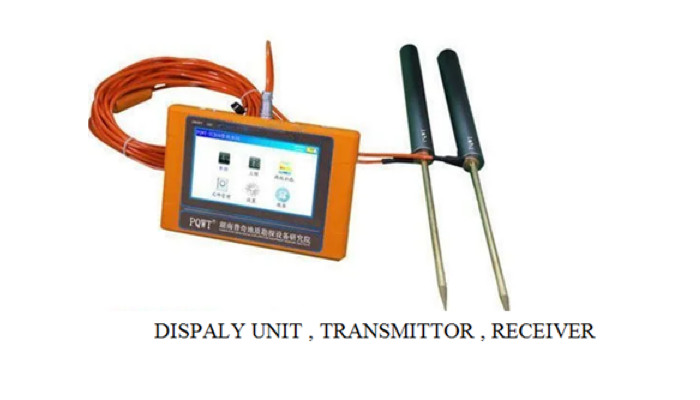
Geophysical prospecting instrument has 3 main units
- Digital display unit
- Transmitter
- Receiver
Triple frequency Electromagnetic wave at a frequency of 170hz for shallow level, 67hz for middle level, 25hz for deep level are used to penetrate earth surface through transmitter rod Once a conducting surface is hit it produces eddy current which again produces electromagnetic waves
Receiver Antenna detects original Electromagnetic waves sent from transmitter antenna and a second wave generated from highly conducting surface i.e water is also detected
After data collection by the unique built-in computing functions, the instrument can Automatically draw curve graph and profile map with one button, according to the profile map, one can clearly understand the geological structure and quickly determine the location of ore body (seam), hollow (cave), water (aquifer) etc.
 underground water using Electromagnetic waves
Application:
From the application point of view to classify, it can be called prospecting meter, water detector, cavity detector, prospecting instrument, instrument engineering exploration, geothermal detector, archeology instrument, logging tools, measuring water detector, water detector, prospecting equipment , prospecting instrument. From the perspective of the measurement field source classification, also known as natural electric field instrument, audio electric field instrument, the earth audio instrument.
The instrument is the use of natural earth field source without going through artificial field that is omitted clumsy power supply system in order to achieve the simple, lightweight instrument.
To download as a pdf Click Here

